School nearby Detskiy Sad 22
Kazakhstan
School nearby Detskiy Sad 22
Detskiy Sad 22
31, Zheltoqsan Street, 020000, Astana, KZ Kazakhstan
contacts phone
:
+7
Latitude:
51.1726821
, Longitude:
71.4144796
larger map & directions
read more
nearest School
63 m
KFA
Zheltoqsan Street 2, Astana
School
read more
245 m
Школа-гимназия № 2 им.Ғ.Қайырбекова,
Astana
School
read more
246 m
State School #2
Seifullin Street, Astana
School
read more
271 m
Complex School #47
Saryarka District
School
read more
288 m
школа-комплекс № 47
Säken Seyfullin Street 21, Astana
School
read more
302 m
Multi Kids
Säken Seyfullin Street 25, Astana
School
read more
579 m
Detskaya Shkola 1
Astana
School
read more
725 m
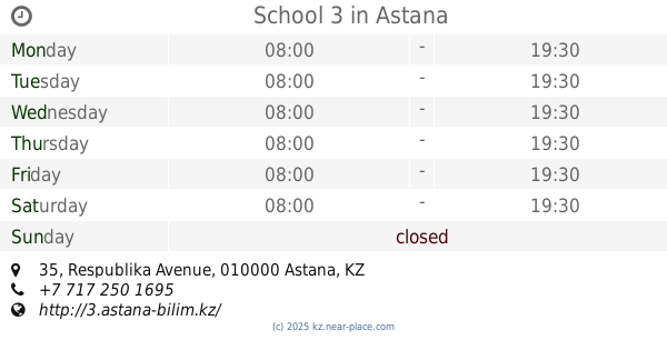
School 3
Respublika Avenue 35, Astana
School
read more
1.063 km
Lyceum 1
Zheltoqsan Street 9, Astana
School
read more
1.094 km
Detskiy Tsentr Razvitiya Bembi
Abay Avenue 28, Astana
School
read more
1.355 km
School-lyceum №56
Gryaznov Street, Astana
School
read more
1.786 km
14 Shkola
020000, Astana
School
read more
1.791 km
Kaz Nuy
020000, Astana
School
read more
2.17 km
Областная специализированная школа-интернат №2
Astana
School
read more
2.192 km
Special School #2 for Talented Children
Сарыаркинский район
School
read more
2.359 km
Лицей Білім инновация
Säken Seyfullin Street 59, Astana
School
read more
2.531 km
Detskiy Sadik Teremok
Constitution Street 5, Astana
School
read more
2.629 km
Detskiy Sad Koktem
Astana
School
read more
2.794 km
Muz.shkola 3
Astana
School
read more
2.845 km
Қарлығаш №12 балабақша
10,, Yegemen Qazaqstan Gazeti Street, Astana
School
read more
3.004 km
Srednyaya Shkola 16
8 020000, Baktyoraz Beysekbayev Street 17/8, Nur-Sultan
School
read more
3.144 km
Консультационно-Образовательный Центр Regent Calderdale
Zhumabek Tashenov Street 17, Astana
School
read more
3.254 km
Podgotovka K Shkole.
Zhumabek Tashenov Street 27, Astana
School
read more
3.534 km
Detskiy Tsentr Asem-Ay
7/1,, Arasan Street, Astana
School
read more
3.601 km
Қарлығаш
Heidar Aliyev Street 8, Astana
School
read more
📑
all categories
Accounting
Amusement park
Aquarium
Art gallery
Atm
Bakery
Bank
Bar
Beauty salon
Bicycle store
Book store
Bowling alley
Bus station
Cafe
Campground
Car dealer
Car rental
Car repair
Car wash
Cemetery
Church
City hall
Clothing store
Convenience store
Courthouse
Dentist
Department store
Doctor
Electrician
Electronics store
Embassy
Establishment
Finance
Fire station
Florist
Food
Furniture store
Gas station
General contractor
Grocery or supermarket
Gym
Hair care
Hardware store
Health
Home goods store
Hospital
Insurance agency
Jewelry store
Laundry
Lawyer
Library
Liquor store
Local government office
Locality
Locksmith
Lodging
Meal delivery
Meal takeaway
Mosque
Movie theater
Moving company
Museum
Natural feature
Neighborhood
Night club
Park
Parking
Pet store
Pharmacy
Physiotherapist
Place of worship
Plumber
Point of interest
Police
Post office
Premise
Real estate agency
Restaurant
Route
Rv park, camping
School
Shoe store
Shopping mall
Spa
Stadium
Storage
Store
Subpremise
Supermarket
Synagogue
Taxi stand
Train station
Transit station
Travel agency
University
Veterinary care
Zoo
sublocality level 1
↑